 Filter: Categories of Wisconsin Historical Images
Filter: FORMAT_DIMENSIONS of 2 sheets each 36 x 22 cm.
Filter: Categories of Wisconsin Historical Images
Filter: FORMAT_DIMENSIONS of 2 sheets each 36 x 22 cm.
| Date: | |
|---|---|
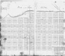
| Description: | This photocopy of a map shows the paper city of Wiota on the East Pecatonica River in Lafayette County. After this village failed to prosper, some of its ... |
| Date: | 1900 |
|---|---|
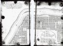
| Description: | This map shows lots, public squares, landing, streets, and promenade of a paper city on a site now in the Town of West Point, Columbia County. The Wisconsi... |
| Date: | 1900 |
|---|---|
| Description: | This Plat map shows the second location of Helena's (of three) on the banks of the Wisconsin River. It also shows the location of shot tower northeast of t... |

| Date: | 1900 |
|---|---|
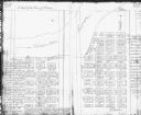
| Description: | This map shows a paper city located where "Grass Creek" meets the Pecatonica River, probably in Iowa County. Number lots and streets with dimensions are sh... |
If you didn't find the material you searched for, our Library Reference Staff can help.
Call our reference desk at 608-264-6535 or email us at: